About Syria
Bosra: A Guide to Its Historic Urban Landscape
Explore Bosra beyond its Roman theatre: understand its layered historic landscape, UNESCO status, archive photographs and property-specific research limits.
In this article
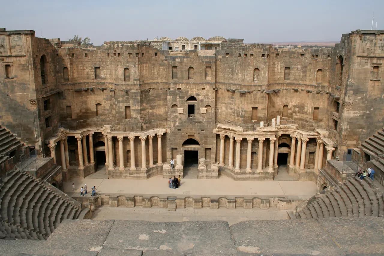

Bosra is easy to reduce to one photograph of a Roman theatre. The theatre deserves its fame, but a better way to understand the city is to look at the relationship between its monuments, streets, later buildings and the people who have used the place across centuries. For anyone researching a location in southern Syria, that wider view matters. A World Heritage designation explains cultural significance; it does not tell you the condition, permitted use or ownership history of a particular building today.
Start with the theatre, then look beyond it
The UNESCO World Heritage Centre's Ancient City of Bosra record identifies a second-century Roman theatre as a central feature of the site. Its value is not simply that the seating survives. UNESCO also describes the theatre's later incorporation into fortifications, an architectural story in which one structure took on another role. From a visitor's perspective, the strong outer form can almost conceal the performance space inside. That is a useful reminder that Bosra was made in stages, not designed as a single frozen ensemble.
The photograph accompanying this page shows the interior of the theatre in October 2007. It is an archive image, not evidence of the monument's present condition or public access. If you see a more recent image online, check its date, viewpoint and source before comparing it with the older frame. Photographs can reveal form and texture; they do not establish that a route is open, safe or maintained now.
Read the city's layers at street scale
UNESCO's account places Nabataean, Roman, Byzantine and Islamic remains within the ancient city. It also points to early Christian ruins and several mosques, including the Al-Omari Mosque. The result is a landscape in which a visitor could move from a monumental theatre to a street, an arch, a religious building or an ordinary frontage and encounter different periods close together. Calling Bosra merely a Roman site would miss that layered character.
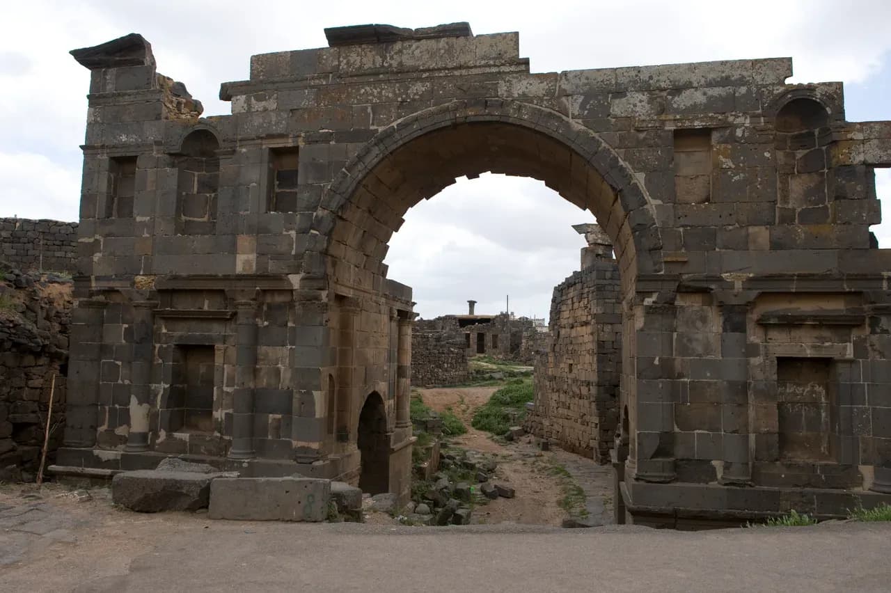
The second archive photograph shows the East or Nabataean Gate in April 2009. Its arch frames a route through the old city; it offers a different scale from the theatre's broad seating. The image is useful for asking how movement and built fabric fit together, but it cannot settle the gate's current conservation status. Nor should a photograph of a street or gate be used to identify a nearby property without an exact address and independent verification.
UNESCO's statement of significance discusses the theatre, cathedral remains, mosques and madrasas as parts of one historic place. Its site record gives a property area and a buffer zone. Those heritage boundaries have a conservation purpose. They are not a shortcut to identifying the boundaries, restrictions or title of an individual home. A buyer considering a building within or near the historic area needs the property's own records and current advice from suitably qualified local professionals.

Understand what the World Heritage status says
Bosra was inscribed on the World Heritage List in 1980. The current UNESCO site record also shows it on the List of World Heritage in Danger from 2013 to the present. That status deserves plain treatment. It signals conservation concern at the heritage-site level; it is neither a street-by-street damage map nor a verdict about every standing building. The page provides links to state-of-conservation reports, which a reader can check for the dated context of a particular UNESCO statement.
Do not use the inscription as a sales slogan. “Near a UNESCO site” says little about a home unless the address and relationship to the designated area are established. Equally, a photograph taken before the conflict should be labelled as archival even if the monument remains recognisable. The past can enrich a location description without being made to certify the present.
Place Bosra within a realistic location brief
Bosra is in southern Syria, and its historic identity may be one reason a reader starts researching the area. A property brief still has to work at the level of a street and a building. Ask for the Arabic address, a location pin, the written property description and the name of the relevant governorate and locality. Compare those items rather than choosing the most familiar label. The Damascus and Rural Damascus guide explains why an administrative name, a map pin and an actual unit should be recorded separately.
Think next about daily life rather than a sightseeing itinerary. What route would residents use for work, school, family visits and supplies? What can be confirmed about the entrance, stairs, water storage, electrical equipment and shared areas at the exact building? A broad regional description cannot answer these questions. Keep dated observations apart from claims made in a listing, and ask a qualified person to assess any technical concern. The property comparison sheet is a practical place to note which details are known, which are estimated and which remain unverified.
Keep heritage, access and legal research in separate files
It helps to maintain three short records. The first is cultural context: UNESCO material, historic photographs, their dates and the features they actually depict. The second is current location evidence: a precise address, recent observations, route information and the date each source was checked. The third is property-specific legal and technical evidence, assembled for an independent Syrian lawyer and relevant qualified inspectors. Mixing the three can make an attractive description sound more certain than it is.
Current travel and access conditions require their own check through official advice and reliable local information before anyone plans a visit. The viewing-trip guide begins with that decision and provides a way to prepare remote questions first. This article cannot determine whether travel to Bosra, a monument or an address is feasible or safe at the time of reading.
Bosra rewards a careful reader because the theatre is only the beginning of the story. Look from the monument to the gate and streets, notice that the city's history extends across several periods, and check UNESCO's dated conservation record. Then put the heritage file aside while examining one property on its own evidence. That is how cultural understanding can make location research richer without substituting for it.
Continue your research
As-Suwayda Governorate: Towns, Landscapes and Local Research
Explore As-Suwayda Governorate by verifying the exact town and address, comparing dated images with present conditions, and checking each building and its records.
Read more
Daraa Governorate: Planning Your Location Research
Research a Daraa Governorate property by moving from regional labels to a verified address, dated local evidence and independent building and document checks.
Read moreSources & review
Last reviewed:
PUT YOUR RESEARCH TO WORK
Start with a place.
Explore Syria’s cities and narrow your property search.